GeoJSON import and export
Regions are exchanged as GeoJSON, in the same shape QuPath uses, so annotations move between SIV, QuPath and analysis scripts. You can also export regions as a mask image.
Export
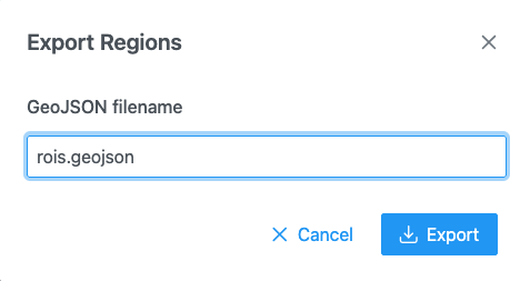
In the Region Editor, click Download regions as geojson
file. The Export Regions dialog proposes <image name>.geojson (or rois.geojson). Click Export.
- The file holds every region of the current image, plus the remaining features of a large region set.
- For a stack opened from a single file, every slice's regions are saved in one file, each with its slice number. For a stack opened from a folder of files, one GeoJSON is saved per slice file.
- Intensity profile lines are never exported.
Save to server
When the host application stores files, Save regions to server opens Save
Regions As with a GeoJSON filename (default <image name>.geojson). If the file exists, the dialog
warns "This file already exists and will be overwritten." and asks for confirmation. Saving regions…
shows progress, with Cancel.
File format
{
  "type": "FeatureCollection",
  "features": [
    {
      "type": "Feature",
      "id": "a1",
      "geometry": { "type": "Polygon", "coordinates": [[[10, 10], [200, 10], [200, 150], [10, 150], [10, 10]]] },
      "properties": { "classification": { "name": "Tumor", "color": [255, 68, 68] } }
    }
  ]
}
| Region | GeoJSON geometry |
|---|---|
| Rectangle | Polygon with a 5-point ring (read back as a rectangle) |
| Polygon, freeform, brush, wand | Polygon; extra rings are holes |
| Multi-part region | MultiPolygon |
| Polyline | LineString |
| Bézier region | Polygon of the flattened curve, with the curve's anchors and handles in properties so SIV can restore it |
properties.classificationholds the classnameand itscoloras[r, g, b].- A region on slice z of a stack carries
geometry.plane = {"c": -1, "z": z, "t": 0}(QuPath's schema). Slice 0 has noplane. - A feature's
idand any otherpropertiesfrom an imported file are kept on export. - Coordinates are image pixels.
Import
Click Import regions in the Region Editor and choose a file.
Importing replaces
Importing a GeoJSON file replaces the regions of the current image. Export them first if you want to keep them.
| Input | How to import | What you get |
|---|---|---|
GeoJSON (.geojson, .json) |
The file's regions. A file with slice numbers (plane.z) is split across the stack's slices. |
|
| Large GeoJSON (1,000,000 characters or more) | A region set, drawn at a level of detail that suits the zoom. See Limits. | |
| Folder of per-slice GeoJSON files | One file per slice, in natural name order (slice_2 before slice_10). A regionset.json in the folder supplies the class tree and style. |
|
Label volume (.nii, .nii.gz, .nrrd) + ontology JSON |
(choose both files) | One class per label. Class names come from a regionset.json, an Allen structure graph (acronyms), or are "label n". |
OME-Zarr store (its labels/) |
The first label image, as a label volume. | |
.zip of any of these |
(zip inside the folder) or from the server | Its contents. |
| From the server | A GeoJSON file, a folder of per-slice files or a label volume picked on the server. |
Reading rules:
classificationmay be a string or{ "name", "color" }. A feature with no classification gets the class Cell.- A single axis-aligned rectangle ring is read back as a rectangle.
- Class colours follow your class list when the class is in it; otherwise the file's own colour is kept for the session.
- A file may carry a
classHierarchy(name,title,parent,color,order) for a class tree, and astyle(fillOpacity,stroke,strokeWidth,labels,highlight). - Supported geometries:
Polygon,MultiPolygon,LineString. Points are not supported.
Errors you may see: "Invalid GeoJson file: must contain the 'features' key.", "Invalid GeoJson file: must contain the 'coordinates' key.", "Error parsing json string: …", "Different size" (a label volume that does not match the image), and "Import discarded" (you changed image while the file was read).
Masks
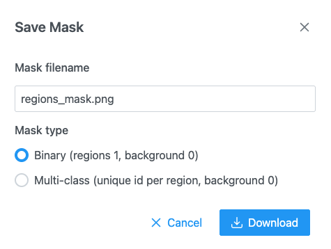
 Download mask of the regions as
PNG saves a mask image the size of the image, for training or analysis. Default name
<image name>_mask.png.
| Mask type | Pixel values |
|---|---|
| Binary (regions 1, background 0) | Regions are 255 (white), background 0. |
| Multi-class (unique id per region, background 0) | Each region has its own id (1, 2, 3…). 8-bit up to 255 regions, 16-bit above. |
- Later regions paint over earlier ones where they overlap.
- The mask covers the regions of the current slice (not the features of a large region set).
- Images larger than 100 megapixels are saved downscaled, with the message "Mask downscaled".
- Rasterizing regions… and Encoding PNG… show progress; Cancel stops.